|
|
|
|
| Context |
A prerequisite to building long-term (decadal) archives of ocean color, in response to the need for assessing the response of the oceanic biota to climatic changes, is to accuratelycalibrate the top-of-atmosphere (TOA) satellite observations, then to validate the surface geophysical parameters derived from these observations, and finally to develop and maintain this capability over long periods of time. Ensuring coherence between the geophysical products derived from different sensors is also an important aspect to consider.
When ocean color observations from different remote sensors are considered as part of the task of data merging, their intercalibration and validation might be facilitated if it could be anchored on continuous long-term in situ stations (IOCCG 1999). Deploying and maintaining moorings or other types of fixed stations that operate in a continuous way is, however, a difficult proposition. Successful examples are provided by the Marine Optical Buoy (MOBY) program (Clark et al. 1997 and 2003), which is maintaining an optical mooring near Hawaii since 1995, and by the Coastal Atmosphere and Sea Time Series (CoASTS) project maintained near Venice (Italy) since 1995 (Berthon et al. 2002 and Zibordi et al. 2002).
In response to these concerns, a project was started in 2000 with the objective of establishing a time series of optical properties in oceanic waters to support the calibration and validation of ocean color satellite sensors. This activity has been named the Bouée pour l’acquisition de Séries Optiques à Long Terme (BOUSSOLE) Project.
Back to
top |
| General objectives |
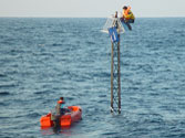
A new type of buoy has been specifically designed for the acquisition of radiometric quantities, and has been deployed in the Mediterranean Sea between the French Riviera coast and Corsica. One general objective is to perform match-up analyses and vicarious calibration experiments for ocean color satellite sensors, based on the data set that is being built from this new buoy. The primary objective of the first deployment, which took place in July 2000 and lasted for three months, was to validate the mooring concept.
The first operational data collection occurred in May 2002, but the entire buoy was lost because of a flaw in the construction of the primary flotation sphere. A redesigned buoy was deployed at the beginning of September 2003 which resulted in three months of successful data collection.
In 4 March 2004, a third data collection sequence was begun and lasted until July 2004, when a rotation of the buoy upper superstructure (i.e., the one that hosts instrumentation) was carried out. Then, the data collection continued until June 2005, when a rotation of the entire buoy and mooring line was accomplished. This was actually the beginning of a nearly uninterrupted succession of deployments. Another objective is to perform vicarious calibration experiments. They should allow the TOA radiance to be simulated and compared to the satellite measurements, in particular for the European Medium Resolution Imaging Spectrometer (MERIS) sensor (Rast et al. 1999). By this way, the need for a change in the preflight calibration coefficients for a given sensor might be evaluated, and its amount quantified. From this data set, match-up analyses shall be also possible for chlorophyll a concentration and water-leaving radiances, as well as algorithm evaluation (atmospheric correction and pigment retrieval). Because of a certain commonality in the band sets of the new generation of ocean color sensors, the data acquired withthe buoy might be used for several of these sensors, and then contribute to the international effort of intercalibrating them and of cross-validating their products, which were amongst the basic goals of the SIMBIOS project (McClain 1998). In addition, some protocol issues (measurements) are specifically linked to the use of buoys, while others, of general concern to marine optics measurements, may find specific answers in the case buoys are used. These aspects are examined, which, to the best of the project knowledge, have not been thoroughly investigated up to now.
In parallel to these operational objectives (i.e., the calibration and validation activities), the assembled data set will be used for more fundamental studies in marine optics and bio-optics. Amongst the questions and topics that might be addressed are the diurnal cycles of optical properties, the response to abrupt environmental changes (storms and so-called red rain events), the relationships between chlorophyll concentration and the inherent optical properties, the role of a fluctuating interface in establishing the radiative regime, the bidirectionality of the radiance field, the annual cycles and interannual variations of the optical properties, the use of these properties as indicators of other biogeochemical properties, and the interpretation of the natural fluorescence signal. Back to top |
| Vicarious
calibration |
The need for vicariously calibrating an ocean color satellite sensor was first demonstrated by the Coastal Zone Color Scanner (CZCS) mission, which was operational from 1979–1986. On one hand, this instrument was not equipped with the necessary onboard devices for the monitoring of
the long-term degradation of the instrument response sensitivity (internal lamps suffered a rapid degradation), and, on the other hand, the mission did not include an extensive vicarious calibration program. In the end, the calibration of the CZCS was never based on a robust scientific capability
and has never been sufficiently confirmed.
The converse situation is illustrated by the Sea-viewing Wide Field-of-view Sensor (SeaWiFS) mission (Hooker et al. 1992). On the one hand the instrument is equipped with a solar diffuser and a full-moon viewing capability which are used to track the temporal stability of the instrument, and, on the other hand, an extensive vicarious calibration and algorithm validation program was set up prior to launch (McClain et al. 1992). The vicarious calibration portion of the latter is based on the deployment of a permanent optical buoy, the MOBY program (Clark et al. 1997), which is moored in Case-1 waters near the island of Lanai in Hawaii. In parallel to this central and key element, extensive campaigns are conducted around the world ocean, in order to collect radiometric measurements and ancillary data in a variety of environments (e.g., Robins et al. 1996, Aiken et al. 1998, and Barlow et al. 2003). These data are used to permanently evaluate the quality of the level-2 products and improve, when possible, the algorithms.
Without ground-truth data—more properly sea-truth data—it is impossible to maintain the calibration of a satellite sensor at the desired level over the full course of the mission, which is generally designed to be on the order of about five years (although many satellites operate for
longer periods of time). This is not due to any weakness in the sensor nor in the onboard calibration devices. This is simply due to unavoidable physical considerations: the goal of modern ocean color sensors is to provide the water-leaving radiance in the blue with a 5% accuracy over
oligotrophic, chlorophyll-depleted, waters (Gordon 1997), which can be expressed as well as an uncertainty of 0.002 in terms of reflectance (Antoine and Morel 1999). Because this marine signal only represents about 10% maximum of the TOA radiance (i.e., the radiance directly measured by
the sensor), achieving this goal requires the instruments involved are calibrated to better than 0.5%, or approximately 1%. This is extremely challenging considering the present technology, and probably will remain an elusive accomplishment.
A successful strategy for ensuring high-quality observations from an ocean color satellite mission is based on a rather pragmatic approach and consists of a) making the best possible effort when initially characterizing and calibrating the spaceborne instrument on the ground, b) using onboard calibration devices or manuvers to track sensitivity changes over time while on orbit, and c) adjusting individual channels to force agreement with the sea-truth data—the basis of the vicarious calibration procedure— which produces a final adjustment for the whole (instrument plus algorithms) system.
Back to
top |
| Moorings
as long-term data sources |
Maintaining a permanent optical mooring is a costly, but pertinent, solution to the problem of how best to collect a significant number of sea-truth data that are needed in the vicarious calibration process. This is easily demonstrated by comparing this option to the usual oceanographic practice of deploying research vessels to various parts of the world ocean.
Past experience has demonstrated that a one-month cruise is able to produce a maximum of a dozen of matchup points when conditions are extremely favorable. This is simply due to the number of conditions that must be simultaneously fulfilled for a measurement to be usable for
the calibration and validation process (clear sky, low wind speed, acquisition within a maximum of 1 h of satellite over pass, nominal operation of the instruments, etc.).
A permanent mooring is well adapted to maintaining a consistent time series of in situ measurements over a long time period, because the people, equipment, and methodologies are mostly fixed. Ensuring the same level of consistency between personnel, equipment, and protocols from different cruises inevitably adds some extra uncertainties in the overall enterprise of data collection and processing.
A permanent station is also well suited for developing and testing new instrumentation as well as new algorithms, and therefore to permanently improve the quality and the variety of products that can be derived from the ocean color observations at the TOA level. It is as well a unique opportunity to establish the cross calibration between different sensors by anchoring them to the same in situ time series. A criticism that is often made of the mooring option is the uniqueness of the measurement site. This is actually not an argument, because the vicarious calibration process is a physical process, which does not require that data from a variety of different environments are collected.
It requests, however, that the maximum of information (quantitatively as well as qualitatively) are collected at the selected site so that the reconstruction of the TOA signal through radiative transfer calculations is performed with the best possible accuracy. This does not preclude, however, that data are collected in other environments for validation of level-2 products and for verification of the calibration obtained at the initial mooring site.
The scheme briefly exposed above (i.e., a permanent calibration site and a parallel program of validation from ships) was adopted by the SeaWiFS Project. It has been a success and this sensor is probably one of the best calibrated ocean color sensors the community ever had, at least until new generation sensors such as MERIS and the Moderate Resolution Imaging Spectroradiometer (MODIS) are operational and demonstrate their potential.
Back
to top |
| Specific protocol requirements |
It has just been said that moorings are adapted to provide large numbers of in situ data points. But what would be the advantage in case these data are not of the desired quality? The question arises because the conditions of measurements on a mooring may degrade the final quality of the data. Buoys are often moving a lot as soon as the sea is not totally flat, so that instruments are instable. They are often made of a large floating body below which equipment is installed so that the shading of the instruments may be significant. The prolonged immersion of instruments is favorable to the development of biofouling. Finally, the number of calibrations that can be performed, which is particularly important to track the temporal stability of radiometers, is depending on the frequency of servicing of the mooring (during which instruments can be exchanged), which might be insufficient in some cases (either because it is inherent to the project organization or because of meteorological hazards).
As a consequence, the qualification of a given mooring program with respect to the ocean color calibration and validation requirements should consider the above points and evaluate whether or not they have been accounted for through a protocol. The data collected by the moored instruments should be, for instance, compared to the same data derived from shipdeployed instrumentation.
Back to top |
|
|
|