|
MEASUREMENT
SITES: THE BOUSSOLE SITE |
| The following three
subsections are describing the main characteristics (1)
of the offshore BOUSSOLE site (32 nautical miles from
Nice), (2) of the transect along
which we are sampling from the BOUSSOLE site to the Nice
Harbor, and (3) of the AERONET
station that is installed within the military premises
of Cape Ferrat. |
| BOUSSOLE site:
Bottom depth |
The site where the mooring
is deployed and where monthly cruises are carried out
is located in the Ligurian sea, one of the sub-basins
of the Western Mediterranean sea (Figure below). The water
depth is varying between 2350 and 2500 m in this area,
and it is exactly 2440 m at the mooring point, which
is by 7°54’E,43°22’N.
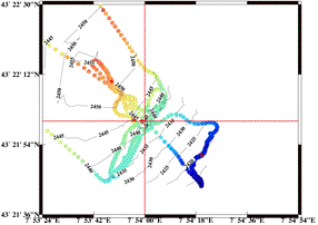
A precise knowledge of the
water depth was critical in order to deploy the taught
mooring that have been developed in this project. This depth was determined by performing several deep
CTD casts, from which the measurement of the pressure,
once translated into a depth thanks to the simultaneous
measurement of the temperature and salinity, was added
to the measurement of an altimeter (the CTD being stopped
at about 10 meters before the bottom is reached). The
water-column thickness was therefore determined with
a <1 meter accuracy. These measurements were used
to calibrate a two-dimensional mapping of the sea bottom
that was obtained from the ship echo sounder. This mapping
revealed a flat bottom characterized by a weak NW to
SE slope (see bathymetry map below).
The tide amplitude, the
dynamic height changes and the water level variations
due to atmospheric pressure changes are all less than
about 50 cm, which is not significant in the frame of
this project. They might become problematic in case a
similar mooring would be deployed in another sea where
such changes would be larger. |
|
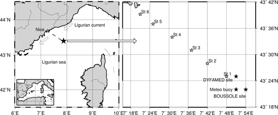
Left map : The Northwestern
Mediterranean sea, with indication (black star) of the
location of our work area. Right map : a zoom from the
general map, showing the position of the BOUSSOLE site
(black star), the DYFAMED site (circle), and of the meteo
buoy (triangle) maintained by the French weather forecast
Agency (“METEO France”). The positions of
the 6 stations that are sampled once a month from Nice
to the BOUSSOLE site are also displayed (open stars).
Back to
top
Bathymetry of the area including
the BOUSSOLE site (at the crossing of the horizontal
and vertical lines). The open stars indicate the location
of the individual deep CTD casts that allowed the echo-sounder
survey (grey dots) to be calibrated in terms of water
depth.
Back to
top
|
| BOUSSOLE site:
Physical conditions |
This site has been selected
in particular because currents are extremely low. This
peculiarity is due to the position close to the center
of the cyclonic circulation that characterizes the Ligurian
sea. The Northern branch of this circulation is the Ligurian
current, forming a jet flowing close to the shore in
the NE to SW direction and creating a front whose position
is seasonally varying, closer to shore in winter than
in summer. The southern branch is a SW to NE current
flowing north of Corsica and the eastern part of the
circulation is simply imposed by the geometry of the
basin.
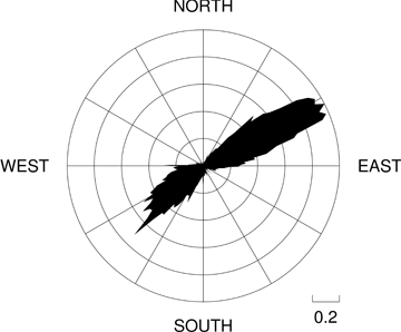
Dominant winds are from
the west to Southwest and from the Northeast sectors
(wind rose below), and are channeled into these two main directions
on the one hand by the general atmospheric circulation
of the region, and, on the other hand, by the topography
formed by the Alps and Corsica. Over the past 4 years
(February 1999 to July 2003) only 5 days were recorded
with an established wind speed above 40 knots, then respectively
34 and 100 days with wind speeds between 35 and 40 knots,
and between 30 and 35 knots. These high wind speeds,
and the associated large swells are concentrated from
November to March.
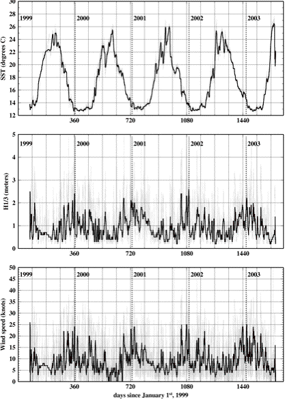
This is as well illustrated
on the multi-panel figure below, where physical conditions are displayed as
a 4-year record of the wind speed, significant wave height
and sea surface temperature (SST). These data are obtained
from a weather mooring, which is distant by two nautical
miles from our station, and which is maintained by Meteo
France, the French weather forecast Agency.
The minimum SST is about
12.7°C (associated with a salinity of 38.4 psu),
which is a constant value reached in winter when the
water mass is fully mixed down to the bottom. This deep
mixing contributes to the formation of the bottom waters
of the Western Mediterranean sea.
Wind rose at the BOUSSOLE
site (data from the meteo buoy maintained by the French
weather forecast Agency).
Time series of the sea-surface
temperature (top), significant wave height (middle; the
H1/3 parameter is the mean wave height computed over
the highest third of the wave height distribution), and
mean wind speed (bottom), as recorded by the meteo buoy
maintained by the French weather forecast Agency in the
vicinity of the BOUSSOLE site. The bold
curves are running averages computed from hourly measurements
(dotted curve).
Back to
top |
| BOUSSOLE site:
Trophic conditions |
Oligotrophic conditions
prevail at the BOUSSOLE site in summer with chlorophyll a concentrations
below 0.1 mg m-3, with minima around 0.05
mg m-3. The higher concentrations are up to
about 2 mg m-3, mostly during the early spring
bloom (February to March). Sporadic and intermittent
enhancements occur in winter when sunny weather occasionally
and temporarily stabilizes the nutrient-rich waters.
Moderate concentrations, between 0.1 and 0. 2 mg m-3,
characterize most of the other periods of the year. This
is illustrated below.
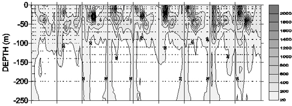
Time-series of the chlorophyll-a
concentration at the DyFAMED site, in the vicinity of
the BOUSSOLE site (figure reproduced from Marty et al.,
2002, Deep-Sea Res.).
|
| Additional activities
in the area |
The BOUSSOLE site is located
in an area that has been defined some years ago as an
area dedicated to scientific work, and where is located
another site where monthly cruises are taking place in
the frame of the “DyFaMED” observation service
started in 1991 (Marty, 2002). This
service collects core data that are put at the disposal
of the entire scientific community (CTD casts, HPLC pigments,
nutrients, oxygen, COD, short-time 14C incubation
primary production). Other non-permanent activities are
carried out occasionally around this site (see the Deep-Sea
Research special issue 49(11), 2002, “Studies at
the DyFaMED (French-JGOFS) time-series station, N.W.
Mediterranean sea).
Back to
top
|
|
|
|