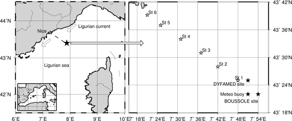
The transect from the coast (actually from
the Nice harbor) to the BOUSSOLE site is characterized
by a permanent front between the waters of the Ligurian
current and the more offshore waters. This front moves
from near the coast (about 10 nautical miles) in spring
and summer to near the BOUSSOLE site in winter.
In addition to classical CTD casts, which
have been already performed in the past along this transect
(non systematically however), we are documenting the
inherent optical properties (total absorption and attenuation,
backscattering at 3 wavelengths and CDOM fluorescence)
at 6 fixed stations, 5 nautical miles away from one another (see map below).
This survey started in July of 2002.
Documenting these properties at this
series of station is also a way to put the observations
made at the BOUSSOLE site into a larger context.
|