KEOPS / SCIENTIFIC AIMS
![]() Objective
1: Identification of the mechanisms of natural iron fertilisation of the Kerguelen plateau
Objective
1: Identification of the mechanisms of natural iron fertilisation of the Kerguelen plateau
( 21-Jan-2004 / sB/mpT)

|
Objective
1
|
|
| (click to go to ...) |
|
The Kerguelen plateau is a unique
natural laboratory in the ocean. It is located in the core of a key oceanic
area in the context of global climate change: the Southern Ocean (Sarmiento et al., 1998)
. The French community has a good knowledge of this
area, supported by previous or ongoing programs (ANTARES, KERFIX, OISO,
CLIOKER). Recent experiments have given first insights into the concentration
of dissolved iron in the water column above the Kerguelen plateau and the
response of the phytoplankton community to natural iron enrichment (Blain et al., 2001; Bucciarelli et al.,
2001)
. In addition, available SeaWiFS data provide a good
description of the spatial and temporal variability of bloom events helping to
choose the appropriate time of the year and location for field studies. Examination of the 5 years of monthly SeaWiFS
images (Fig 2) suggests two distinct regions of high primary productivity in
the austral summer (December, January, February) over the Kerguelen Plateau.
The one lays on the shelf (of depths < 200 m) north of Kerguelen and the
other over the shallow plateau (between the 500 and 1000 m isobaths) widely
developed south of Kerguelen. The two regions are often well separated in SeaWiFS images by the Polar Front or a branch of the
Antarctic Circumpolar Current (ACC) which are strongly attached to the shelf
edge just south and east of Kerguelen (between the 200 and 500 m isobaths)
(Park et al., 1998). According to the available buoy drift information (Projet
Marisonde, 1979), this narrow branch of the current has a relatively strong
speed of 20 to 40 cm/s, respectively, south and east of Kerguelen. The former
region has been studied for biogeochemical parameters by Blain et al. (2001)
who relate the high primary productivity of the region to natural iron
fertilization that has two possible sources: 1) lithogenic inputs from the
islands via atmosphere and 2) inputs from the deep waters. Atmospheric
deposition of iron (see discussion in objective 2.2) is probably not a major
source of iron for the surface water of the southern ocean. considering a
general northeastward surface wind drift at the KEOPS site, this assumption is
also probably valid for in the studied area. However this will be checked.
Therefore, the most likely source of iron in the latter region south of
Kerguelen (which will be the major KEOPS site) is the deep water of the Kerguelen plateau.
Our first objective is to
understand which mechanisms are responsible for the enrichment of deep waters
with iron.
The following hypotheses will be tested 1) Before reaching the
site where deep waters are upwelled, they circulate around the plateau in
contact with the margin. Sediments from the continental margin rich in organic
matter and characterised by a thin oxygenated layer could favour the release
of iron to the water column directly
from interstitial waters or by resuspension in the water colum. 2) The
remineralisation of sinking biogenic material after a massive bloom in the
surface waters of the plateau contributes to iron enrichment of deep waters.
The release from the shelf sediment which
is highly enriched with organic matter can also be a major source of iron.
3) The lithogenic particles issued from the weathering of the island sink and
dissolve in the water column.
Our second objective is to understand what is the
major mechanism of the upward transfer of iron, from deep waters to the surface
layer?
Before addressing this important topic, we summarise first the background dynamics over
the Kerguelen Plateau. According to the KERFIX currentmeter data (Park et al,
1997), currents near the western escarpment south-west of Kerguelen are dominated
by semidiurnal tidal currents and inertial currents (15.7h), with an amplitude
of about 20 cm/s. In the lower frequencies, shelf waves (of periods of 4-5
days) and mesoscale waves (of periods of 2 to 6 months) are present, although
they are much less energetic than tidal or inertial currents. The time-mean
current there at 200 m is of the order of 5 cm/s. Around the Kerguelen Plateau
escarpment, the general circulation seems to be anticyclonic (or
counterclockwise in the SH), which is discernible from the subsurface property
distribution. This anticyclonic circulation is most clear along the eastern
escarpment where exists an along-slope, north-westerly directed cold tongue
(Park et al., 1997). This cold tongue, indicative of advection of cold subsurface
water originating from the south (Park et al., 1998), has recently been
confirmed by a high-resolution temperature map at 100 m (Fig 4) using data from
instrumented penguins (Charrassin et al., 2002).
|
|
|
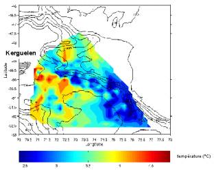
Figure 4 : Surface plot of sea water temperature
over the Kerguelen plateau at two depths (100m (left) and 0 m (right)) during
summer 1988-2001. The temperature have been measured using sensors attached to
penguins. The location, latitude and longitude of the animals was provided by
GPS system and depth using pressure
sensors. J.-B. Charrassin, Y.-H. Park et C.-A.
Bost, , 2002.
The observed northwestward current, which is opposed
to the dominant westerlies and thus to the general eastward flow of the ACC,
cannot be explained by a wind-driven current mechanism. Rather, it hints at the
forcing dynamics coming from a tidal current-bottom topography interaction that
generates along-isobath residual currents flowing counterclockwise in the SH
(NW direction in our eastern escarpment). This leads to the hypothesis:
There is a strong interaction between tidal currents
and the bottom topography. especially over the steep eastern escarpment of the
Kerguelen Plateau, generating the northwestward tide-induced residual current.
Theories and observations (e.g., Robinson, 1983; Holloway and Merrifeld, 1999;
Merrifeld et al., 2001) show that such an interaction over a steep escarpment
can generate also internal tides that propagate both towards the shallow shelf
and the deep abyssal region. Strong activity of internal tides concentrated
over the shallow part (< 1000 m) of the Kerguelen Plateau has recently been
suggested both from satellite altimetry and numerical tide modelling (Le
Provost et al., 2001), which leads to the hypothesis:
Internal tides above the shallow Kerguelen plateau
transfer Fe enriched bottom water into the surface layer. The internal tide
activity above kerguelen plateau and the importance of internal tides in
transporting Fe to the surface mixed layer will be investigated. This hypothesis
is supported by the fact that internal tides eventually cascade into
turbulence, thus providing enhanced vertical mixing within the water column.
It is also expected that the strongest vertical excursion of internal tides
occurs
in the permanent pycnocline that is observed between the 200 and 300 m depths,
or just below the winter mixed layer depth (that is found at < 200 m on the
average, compared to the summer mixed layer depth at about 50 m) (Park et al.,
1998). Although internal tides should exist all the year round, it is likely
that those in the austral winter will be most efficient for eddy fluxing of
near bottom water across the permanent pycnocline into the mixed layer, simply
because of the closeness of the base of the winter mixed layer and the top of
the permanent pycnocline where internal tide activity should be strongest. The
transferred iron into the winter mixed layer could therefore be used for summer
phytoplanctonic blooms
so the specific questions related to the
objective 1 are
F Is there a northward tide induced resulting
current along the eastern slope of the Kerguelen plateau?
F Is there internal tide activity above the
Kerguelen plateau and what is its importance for iron transport to the surface
layer?
F What are the processes which result in iron
enriched deep water?
F What is the magnitude of the iron flux from
deep water to the surface layer?
![]()