The top-of-the-atmosphere radiometric vicarious
calibration is a challenging process, where high-quality
data from several sources have to be put together, forming
inputs to, and boudary conditions of, radative transfer
calculations. This calculations are supposed to provide
the top-of-the-atmosphere total radiance, to be compared
to the same quantity as measured by the satellite-borne
sensor. The principle of this calibration is exposed
below, before a tentative performance budget is proposed
and prelimianry results are shown for the MERIS sensor.
Principle
Two main
vicarious calibration paths exist to produce
ocean color products of the desired accuracy, i.e.,
water-leaving radiances within an uncertainty of about
5% in the blue for an oligotrophic ocean (Gordon 1997,
and Antoine and Morel 1999). The first one is usually
referred to as vicarious calibration, and consists
in forcing the satellite-derived water-leaving radiances
to agree with a set of in situ water-leaving radiances
(match-up analyses). A set of vicarious calibration
coefficients is obtained, which is applied to the top-of-atmosphere
(TOA) total radiances measured by the sensor. The second
procedure, which is also an indirect (vicarious) calibration
is sometimes referred to as a vicarious radiometric
calibration, and consists in simulating the TOA signal
that the sensor should measure under certain conditions,
and to compare it to the measured signal.
One of the difficulties of the first type of vicarious
calibration is that it is dependent upon the procedure
used for the atmospheric correction of the TOA observations.
Even if it is admittedly less dependent upon the selected
set of in situ water-leaving radiances, these measurements
also contribute to the final accuracy. The advantage
of this technique is, however, and besides the fact that
atmospheric measurements are not needed, that the marine
signals delivered by several sensors that use different
atmospheric correction algorithms can be cross-calibrated provided that the same set of in situ waterleaving radiances
is used to perform the vicarious calibration. This is
presently the case, for instance, for the SeaWiFS and
OCTS sensors.
Inconveniences of the vicarious radiometric calibration
is that it requires a set of in situ measurements that
is usually difficult to collect, among other things because
a high accuracy is needed. In addition to the in-water
measurements of the water-leaving radiances, this data
set includes sea state and atmospheric pressure, ozone
concentration, aerosol optical thickness, aerosol type,
and even aerosol vertical profile if the aerosols reveal
to be absorbing. If this data
set is successfully assembled, the advantage of the vicarious
radiometric calibration is that it is independent of
the atmospheric correction algorithms, so that the TOA
signals of various sensors can be cross-calibrated. Then
it is up to any user to apply its preferred atmospheric
correction to these TOA signals. The marine signals in
that case might be inconsistent if significant differences
exist in the various atmospheric corrections.
The greatest difficulty of the vicarious radiometric
calibration lies in the estimation of the aerosol optical
thickness, phase function, and single scattering albedo.
These parameters are accessible through the inversion
of sun photometer measurements, yet uncertainties inevitably
occur when applying such methods, for instance because
of multiple scattering, of perturbations from the ground
reflectance, of uncertainties in the photometer calibration.
Assembling all data needed for these vicarious calibration
experiments are often compromised only because aerosol
parameters are not accurate enough. The principle is
illustrated on Fig. 35 A practical example will
be provided later on (Sects. 10.3 and 10.4).
The Rayleigh scattering above clear waters method actually
follows the same principle as the full radiometric vicarious
calibration (the scheme displayed just above), but by
using assumptions about, instead of measurements of,
the various input parameters. This is particularly critical
for the water-leaving radiances and the aerosol parameters.
The final accuracy of this method cannot be better than
that of the vicarious calibration procedure, except in
a situation where the measurements used in the latter
would be of very poor quality (or even erroneous).
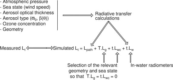
Overall logic of the top-of-the-atmosphere
vicarious radiometric calibration of ocean color sensors.
L stands for radiance, and the subscript “t” is
for total (TOA), “G” for sun glint, “wc” for
white caps, and “w” for water-leaving; “T” and “t” and
the direct and diffuse atmospheric transmittances, respectively.
9The true,
direct, calibration in principle consists in measuring
the signal from a well-known standard, and is performed
before launch for space-born sensors. After launch, only
indirect (vicarious) procedures are possible.
10Except
in situations where the atmosphere would be significantly
different from the atmosphere present when performing
the in situ measurements used for the vicarious calibration
exercise.
11When
these measurements are not available and are replaced
by averaged, reasonably estimated, values, the radiometric
calibration here described comes down to the so-called Rayleigh
calibration (or calibration over the Rayleigh),
also planned within the frame of MERIS calibration and
validation issues.
Back to top
Performance budgets
It is in practice impossible to establish
an a priori full performance budget, which should account
for both unpredicted or unknown experimental sources
of error (such as unidentified calibration deficiencies,
difficulties encountered at sea, etc.) and theoretical
limitations of the measurements themselves. The former
are not totally known before starting the measurement
sessions.
The budget presented below
is therefore a tentative one, and any number provided
in terms of percent error should be considered with caution.
When the information necessary to confidently estimate
the contribution of a given process to the error budget
was missing or insufficiently known, this contribution
has been assigned a somewhat optimistic value.
Each term that may have some impact on the modeling
of the total radiance at the top of the atmosphere ),
which is the sum of the atmospheric path radiance ( )
and of the product of the water-leaving radiance () by
the atmospheric diffuse transmittance (), is examined
below. At the end, the uncertainties on all terms are
considered as random, Gaussian distributed, independent
one of each other, so that the final error budget is
computed as the square root of the sum of the squares
of the individual error terms. The extent to which deviation
from this hypothesis may impair the correctness of the
final error budget has not been assessed.
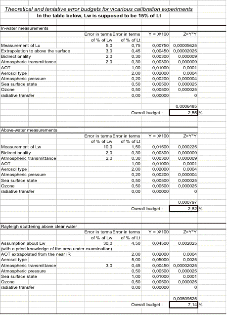
Performance budgets:
In-water measurements
The routine operations on the BOUSSOLE buoy should provide
the measurements of , , and (nadir) at 5 and 9m. The
basic operation consists of estimating the water-leaving
radiance, from these in-water measurements, and in particular
from . Evaluation of above-water techniques for the measurement
of will be also tentatively set up (using a SIMBADA instrument),
and will be examined later (Sect. 10.2.2).
The uncertainty to which Lu is measured is now considered
as being of the order of 5% when carefully performing
the measurements with well-calibrated instruments.
Extrapolation to null depth:
Here the problem is to compute the diffuse attenuation coefficient for the
radiance along the nadir direction, , from the measurements performed at
two depths on the buoy (nominally 5 and 9m); let us refer to it as . This
value of is in principle used to compute the upwelling nadir radiance just
below the surface, , through
where is about 5m.
Three important points intervene here, namely the intercalibration
of the instruments at the two depths, which is assumed
to be properly established, the correct estimation of
the depth of the measurements, and
finally the representativity of to perform the extrapolation
of from 5m to just below the sea surface.
For clear waters (i.e., about 0.02m in the blue), a
large uncertainty of 1m on the exact depth of measurement
would lead to an error equal to , i.e., a 2% uncertainty
on the estimation of . Conversely, if it is assumed that
is correctly estimated, an uncertainty of 10% on would
lead to an uncertainty equal to , i.e., an uncertainty
of 1% (resp. 2%) on if is taken equal to 5m (resp. 10m).
These numbers become 2.5% and 5% for , i.e., for mesotrophic
waters, also typical of the BOUSSOLE site when the chlorophylla
concentration reaches about 0.3mgm. What does ``resp.''
stand for?
The attenuation coefficient for the upwelling nadir
radiance is known to vary a bit within the very upper
layers of the ocean (2-5m), so that it is timely to examine
whether or not remains the relevant coefficient to perform
the extrapolation of measured at 5m to the level. The
results of radiative transfer computations (Hydrolight
code) show that a maximum difference of 5% exists between
and for a chlorophylla concentration of 0.3mgm and a
solar zenith angle of 45, which translates into a maximum
error in of 1.25% when using KL,5-9 to perform the extrapolation,
and when is about 0.05m (i.e., a chlorophylla concentration
of 0.3mgm). This error could be significantly reduced
by correcting the values of following what can be learned
from the results of radiative transfer computations.
At the end, assuming an average error of 3% on the
estimation of , because of uncertainties in the extrapolation
to the level, seems realistic.
12The
distance between the 2 depths of measurements is exactly
known ; the depth in question here is that depth
Z from which the extrapolation to just below the surface
is performed through : Lu(0-) = Lu(Z) exp(KL . Z).
Back to top
Bidirectional and transmission
effects:
The in-water measurements provide the upwelling radiance at nadir, which has
to be transformed into the upwelling radiance for the direction below water
( ) corresponding to an above-water zenith angle (), itself corresponding to
a given viewing angle from the satellite, . The transformation is simply performed
by ratioing the -factor at nadir to the -factor for the direction . The uncertainty
is here only in the relative values of at these two directions (in a match-up
configuration, the difference between both will be minimized, i.e., ). In the
blue, where the geometry of the light field is not much depending on the particle
phase function, the ratio of the -factors is probably correct within a very
few percents; a 2% uncertainty will be assumed here.
The last step to get the water-leaving radiance is
to multiply by the expression , which accounts for the
transmission across the interface, where is the Fresnel
reflection coefficient for the water-air interface and
is the refractive index of water. This step does not
introduce any error as far as and the sea surface is
approximately flat (wind speed less than 15kts).
Atmospheric transmittance :
The water-leaving radiance, , has to be multiplied by the atmospheric diffuse
transmittance, , before it can be added to the atmospheric path radiance.
If the expression in use for computing are considered as valid (Wang 1999),
the largest source of uncertainty is the aerosol optical thickness, which
has a small impact on . A factor of two in (from 0.1 to 0.2) translates as
a 2% error on at 443nm, which means a 2% uncertainty on the product .
In the green domain ( nm), another source of uncertainty
is the ozone content of the atmosphere. When nm, the
Rayleigh optical thickness is about 0.09 and the ozone
optical thickness is about 0.03 for an ozone content
of 350DU. The uncertainty in corresponding to an uncertainty
of 50DU would be of the order of 0.5% for viewing angles
less than 45 (with, for instance, .
Back to top
Above-water measurements
The uncertainty to which is derived from
the radiance measured above the sea surface (which includes
and surface reflection effects), is now considered as
being of the order of 10% (Hooker et al. 2002; Hooker
and Morel 2003), at least when performed in well-controlled
experimental conditions and in excellent environmental
conditions. Because the measurements are taken from
above the sea surface, the uncertainty attached to
the extrapolation of in-water measurements from depth
to just beneath the surface does not enter into account
here. The same uncertainty is attached to the determination
of bi-directional effects (Q factors) as well as to
the calculation of the atmospheric diffuse transmittance.
Atmospheric path radiance
The uncertainties when calculating the
atmospheric path radiance are now examinea, as originating
from the uncertainties on the various parameters entering
into its computation.
Atmospheric pressure :
Atmospheric pressure, , is known to better than 0.5%
(i.e., 5hPa). The changes in the path reflectance due
to changes in can be expressed as (Antoine and Morel
1998):
where is the ratio of the Rayleigh optical thickness
to the total (i.e., aerosol plus Rayleigh) optical thickness.
In the worst situation, where (no aerosols), the error
in is directly transferred onto (it is actually a little
less (Gordon et al. 1988). It will be also less as soon
as the AOT is not zero. A 0.2% uncertainty is assumed
here when the atmospheric pressure is known (local measurements
from the meteo buoy in the vicinity of the BOUSSOLE site).
Sea surface state :
Quantification of the uncertainty due to an incorrect representation of the
sea surface state is not really possible, and it would be probably useless
because of the large uncertainties that remain in the parameterization of
the surface wave slope probability distribution as a function of the wind
speed. A tentative value of 0.5% is assumed here for the uncertainty introduced
by these surface effects in the computation of at the TOA level, with the
underlying assumption that experiments are only performed for days of calm
weather.
Aerosol optical thickness :
The AOT should be known to better than 0.01 in absolute units (Fargion and
Mueller 2000). The relative changes in due to changes in AOT in the blue
and green domains (i.e., around 440 and 550nm, respectively), , are of the
order of 0.1, e.g., see Fig. 5 in Antoine and Morel (1998). An uncertainty
of 0.01 in should, therefore, translate as an uncertainty of 0.001 in , which
corresponds to about 1% of when , and to about 2% of for the same value of
the AOT. The uncertainties are slightly less as soon as is greater. These
two values (1% and 2%) are taken here. Note that the corresponding numbers
become 2-3% at 865nm.
Aerosol type :
Retrieving the aerosol type, actually the aerosol volume
scattering function (VSF) and single scattering albedo,
is much more difficult than retrieving the AOT: firstly
because the retrieval is based on inversion of sky radiance
measurements, which are delicate to perform with the
desired calibration constraints, and, secondly, because
the inversion itself necessarily uses assumptions and
is also subject to uncertainties.
In order to minimize the impact of uncertainties on
the aerosol type, situations where the satellite data
and external information (wind direction, independent
observations, etc.) are both available will be selected,
in such a way that there is every chance of being in
presence of maritime aerosols. Note that information
about the relative humidity (RH) at the sea level will
be available from the measurements of the meteo buoy
located in the vicinity of the BOUSSOLE mooring. =Table15.tex;''
It is, therefore, considered here that the uncertainty
is entirely due to the uncertainty on RH (the value itself
or the vertical profile), for maritime aerosols conforming
to the description of Shettle and Fenn (1979). From the
results of radiative transfer simulations performed with
these models, it appears that an uncertainty of 15% in
the relative humidity (RH equal to 70% or 99% instead
of 80%) leads to a 2% uncertainty in the computation
of when and . This uncertainty is closer to 5% in the
NIR (nm).
Maintaining this level of uncertainty means that the
vicarious calibration experiments have to be performed
for values as low as possible and for high solar elevations
(the minimum solar zenith angle at the BOUSSOLE site
is about 21o).
Back to top
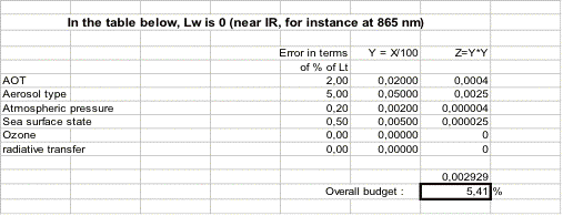
Ozone content :
The importance of ozone content investigated here is
its effect on the calculation of (the other effect has
been already considered in the calculation if the atmospheric
diffuse transmittance). Ozone does not strongly affect
the blue bands, which are the most critical for ocean
color. A null impact on is considered here.
For the green band, the problem is different because
the ozone absorption is there at its maximum, with an
optical thickness of about 0.03 at 550nm when the total
ozone amount is equal to 350DU. The impact on remains,
however, extremely weak, i.e., less than a 5% difference
between for an atmosphere with a standard ozone amount
(350DU) and an ozone-free atmosphere. The typical uncertainties
in the ozone amount (i.e., 20DU) should, therefore, be
without significant impact on the computation of (less
than 0.5%).
The calibration uncertainty has been already considered
when examining the uncertainty due to incorrect determination
of the AOT and aerosol type.
In principle, a valid radiative transfer code, when
fed with accurate inputs, provides an exact answer in
terms of radiance. It is, therefore, assumed that the
modeling itself does not introduce any additional uncertainty.
Back to top
Marine contribution
to total radiance
In clear oligotrophic waters, reaches its maximum in
the blue, and corresponds to about 15% of the TOA total
radiance at 440nm when the AOT is 0.05. Conversely, experiences
minimum values in the green, and corresponds for instance
to about 5% of the TOA total radiance at 550nm when the
AOT is 0.3. Consequently, the various uncertainties in
the estimation of as given above in terms of percentages
, correspond to errors in ranging from % to %.
The various terms are summarized in the tables below,
and following three different configurations concerning
the estimation of the marine and atmospheric contributions
to the TOA total radiance: inwater measurements of and
measurements of the aerosol properties, above-water measurements
of and measurements of the aerosol properties, and, finally
(and tentatively), estimate values for the water-leaving
radiance and aerosol properties (the so-called Rayleigh
scattering above clear water technique).
Back to top
Conclusions :
In summary, the values in the tables below show that
a 2-3% uncertainty in the simulation of the TOA total
radiance can be reached in extremely favorable conditions.
Considering the possible type and range of uncertainties
that are possible, a more realistic estimate of the accuracy
to which the vicarious calibration can be performed would
be approximately 5% in the visible part of the spectrum.
Back to top
A practical example
The inversion algorithm that is suggested in Sect. 7.6
not only permits the characterization of the micro-physical
properties of the aerosols providing the refractive
index, but also permits to have a knowledge on the
aerosol phase function which is a key parameter in
the estimation of the atmospheric radiance and transmittance.
The proposed algorithm can thus be used to lead a vicarious
calibration of ocean color sensors.
The focus here is on the vicarious calibration of MERIS
in the NIR band at 865nm. The sun photometer (Sects. 3.3,
4.3, and 5.3) is used to provide the necessary information
about the aerosol properties. The procedure for the vicarious
calibration is outlined as follows:
- The aerosol
refractive index is derived with the inversion algorithm;
- The optical depth and Angström exponent are
measured; and
- The top of atmosphere radiance is computed with the
OSOA radiative transfer model for similar geometries
of MERIS scenes on the basis of the aerosol optical
properties, which is compared with the top of atmosphere
signal recorded by MERIS.
Some restrictions and
assumptions should be made, however, to apply the vicarious
calibration technique:
- The ocean is assumed to be black at 865nm
which is realistic in the Mediterranean Sea (open
ocean waters), so no marine signal was included in
the computations;
- The MERIS images were selected for geometrical
conditions that permit to aim at the vicinity
of the ground photometer avoiding the glint;
- Because
of the closeness of the land in each image, the
aerosol properties may exhibit a strong spatial variability
at the land-ocean interface, so the aerosol model
derived from the coastal photometer will be applicable
to MERIS marine pixels only if a spatial homogeneity
of the aerosols is observed in the study area (this
constraint is restrictive and substantially reduced
the number of available satellite images for the calibration);
- For each selected image, a subscene of 1010 pixels
is extracted far enough from the coastline (typically
at a distance greater than 6km) to avoid the adjacency
effects on the radiance measured by the satellite
sensor (Santer and Schmechtig 2000); and
- After correction
for the eccentricity of the Earth orbit, the
top of atmosphere radiance is averaged over this sub-scene.
Rigorously, the inversion algorithm is applied on ground-based
measurements collected at the time of the satellite overpass
(around 1000GMT for the Villefranche site) so that the
simulated radiance is consistent with MERIS data. Nevertheless,
it happens that measurements are not available at the
time of overpass; either they are missing or of bad quality.
For such situations, the aerosol model derived from the
inversion of the closest (in time) measurements of satellite
overpass is used to reconstruct the top of atmosphere
signal. This is possible provided that stable conditions
are observed during the day. The daily variation of the
Angström exponent is used to check this assumption.
Back to
top